
Boundary County Air Services
Boundary County Airport 65S Eckhart International Airport 1S1
AWOS: (208) 267-3995 or Frequency 132.575
Great stories about local pilots!
DEPARTMENTS
HOT LINKS
General Information Latitude: 48�43.5' TPA: 3100' Longitude: 116�17.6' Fuel: Jet A -- 100LL Elevation: 2331' FSS info: 1-800-527-3960 CTAF: 123.0
Runway Information Length: 4000' Width: 75' Headings: 20/02 Lighting: VASI on NE end Runway 20 PCL (5 clicks)
For further information |
||
|
Eckhart International Airport Ekhart International Airport, situated near the Idaho/Canada border near Porthill, is a fair-weather grass strip maintained under contract with the Idaho Department of Transportation aeronautics division. The strip is open to the public, though there are no services available. The strip is a customs landing rights airport, with radio traffic monitored by U.S. Customs agents at Porthill.
Latitude: 48�59.5' Longitude: 116�30' Elevation: 1756' CTAF: 122.8 Operational Restrictions: Recommend landing Runway 33, takeoff Runway 15 when weather conditions permit. Not maintained for winter use. Numerous obstructions on approach to Runway 15.
Runway Information Length: 3650' Width: 175'
Surface is turf in good condition; Runway 33 edges marked with white rocks. No lighting. Aircraft parking limited to two hours in U.S. Customs Terminal area.
For further information |

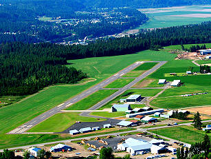 The Boundary County Airport lies two miles northeast of Bonners Ferry, Idaho, providing a scenic destination spot or resting point for all flyers. Some of the services available at the airport include overnight hangars for corporate aircraft, courtesy/rental car, pilot's lounge and supplies, flight instruction and airframe and power plant repair and maintenance and one restaurant within walking distance; the Three Mile Cafe, (208) 267-3513.
  General Information